File: <Viking
Waterway.htm> Archeology Index Viking Index <American Archeology> <Home>
|
For teaching purposes; Quote cited references only Ancient Emigrations To America |
|
VIKING WATERWAY Summary
of Article by Karl Hoenke &
Myron Paine Please CLICK on following
subjects for details & images to enlarge: The
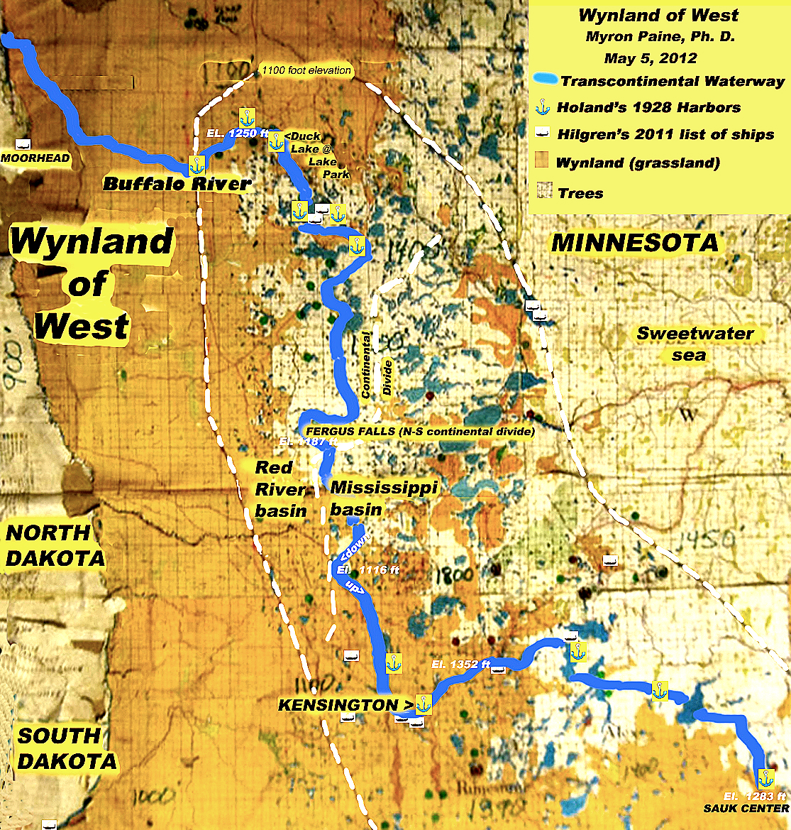
Viking Waterway allowed material to be transported from the Red River Valley
to the Mississippi River
Valley. Three important water communication
networks meet in Minnesota. Drainage
to the north via the Red River
reaches Hudson Bay and the There are four principal histories
that converge in Minnesota: (1) The
ancient copper trade, which enabled the Bronze
Age in Europe and the Mediterranean. (2) Viking explorers before 1000 AD and
Lenape settlers from 1,000 to 2000 AD.
(3) The Lenape migrations from Greenland to the Atlantic coast of North America from
1354 AD to 1362 AD, which are documented in the Maalan
Aarum. (4) The Scandinavian rescue mission led by
Paul Knudson from 1354 to 1362 AD. The Minoans reached England to
acquire tin, and the Baltic Sea
to obtain amber. But it has never
been considered that Minoans and other explorers of the Old World reached
North America in Pre-Columbian times.
Thus 1,300 years of copper movement to the Mediterranean remains unacknowledged. From about 2500 BCE to 1200 BCE great
quantities of pure copper were taken from the area around Lake Superior, down the Mississippi River to Poverty Point, Louisiana. There it was prepared for shipment and
freighted from the Gulf of Mexico to
Europe and North Africa, with the aid of the Gulf
Stream for propulsion. The
massive earth modifications that are still visible along this route were
probably the work of the builders of the waterway during the 2500-1200 BCE
periods. The earth sustained
a serious catastrophic event sometime around 1200 BC, which devastated
civilizations in the Mediterranean
and Asian areas. Copper mining in the
Keweenaw Peninsula of Michigan
ceased and changes are observed throughout the archeological record of
central North America. The end of the
Bronze Age in Europe coincided
with the end of the major copper mining and trade in America. There remain about 10,000 mining pits
around Lake Superior of the
ancient miners. There are also
ancient harbors, Mooring Stones and
other artifacts along the entire waterway.
A very large number of workers would have been required to construct
so many large earthen modifications that are associated with the copper
trade. However, burials and the remains of ships have not been
found, albeit wooden vessels disentegrate over time and cremation leaves
scant evidence. Nevertheless,
publication in scientific journals for this theory is lacking. From 1940 to 1956 Reider T. Sherwin
published a series of books named "The
Viking and The Red Man.," in which there were over 2,500
comparisons between the Algonquin (Lenape) and Old Norse. Viking explorers discovered the American
Mid-continental Waterway and used it to transport copper. Viking began to range out from Scandinavia
in the 8th Century to terrorize In the Maalan
Aarum record
the Lenape left Greenland around 1350 AD when the climate became too cold for
survival. They walked across the
frozen sea to the mouth of Hudson Strait,
across the Ungava Peninsula,
down to Hudson Bay and on to
the forested land south. Those people
were kinfolk or descendants of earlier Viking settlers who had mixed with
native people. The American Vikings
vanished from history but emerged as the Lenape on the East Coast when
European colonists arrived. European
settlers on the east coast from North Carolina to New York and up to the
source of the Hudson River encountered
the Lenape from Greenland. Kinfok of
the Greenland Lenape settled on the coast from New York to the Canadian Maritimes. These people had sailed directly from
Greenland to America. The Beothuk (a
Newfoundland tribe) means "Sail direct." The Beothuk and other Norse, who sailed directly to America,
also called themselves "Lenape."
Besides Norse heritage and the Old Norse language, the Greenland
Lenape may have passed their religion to their descendants for centuries. In 1820 the last of the Lenape storytellers
transferred the Lenape history to Moravian priests doing missionary work in
America. This history was embodied in
a collection of 184 "sticks" upon which drawings were etched and
served as prompts to the storyteller who studied each drawing before reciting
the verse that were memorized long ago.
They are recorded in the Maalan Aarum,
which means "Engraved Years." The Maalan
Aarum relates that in James Bay the population increased by
hunting whales and wild geese, and mentions the first meeting of the leaders
on North American soil. Also included
is an account of the rejection of the Norwegian rescue fleet, of the death of
Norwegian Paul Knudson, of the Lenape retreat to James Bay and of the division of the Lenape in an attempt
to move south to warmer weather.
Their journey took them south, up the Red
River between Minnesota and the Dakotas to Sisseton, South
Dakota. As the Little Ice Age
intensified (See: Climate ) they
migrated south along the Big Sioux River
to Minnehaha County, South Dakota.
Then drought dorve them east across southern Minnesota. Opportunities for survival led them down
the west bank of the Mississippi
until they reached Missouri; then up the Ohio
River Valley. Around 1470
the population divided with the Lenape tribe going east to the Atlantic Coast and the Southern Lenape
going south. Shawnee means
"south," and the Lenape later were called "Shawnee." Both Lenape and Shawnee were believed to
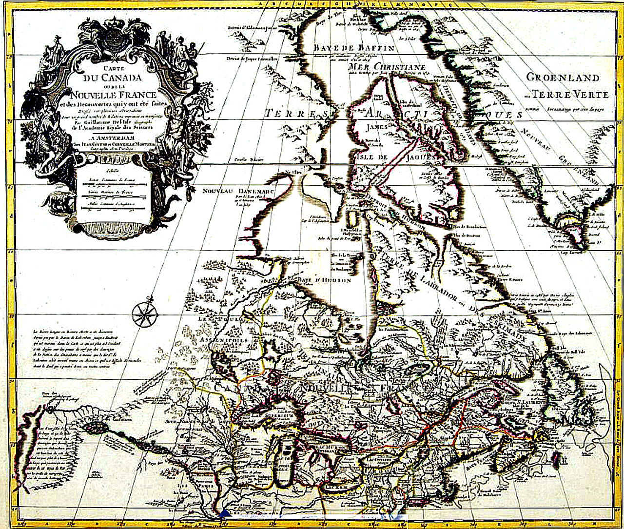
be Christians by Paine (2007 & 2008). A map was produced by a French
voyageur around 1703, which labels the land between the Nelson, Lake
Winnipeg, Red River A section from Hjalmar Holland's 1958 book
relates how King Magnus sent a rescue mission to America, which was a century
before the Columbus "Discovery."
The rescue began in Bergen, Norway in 1354 AD (Holland 1958). The
Maalan Aarum. Lenape historians after 1370 AD noted that the
rescue mission was rejected because Paul Knudson, while returning to
Greenland perished at sea. The rest
of the rescue group remained in Minnesota. Hoenke & Paine believe that the
early copper seekers and later Vikings constructed some of the earthen structures
and harbors that are found along the Waterway. During the initial discovery of a mooring stone Dr. Paine also
noted a straight shore and rectangular corners in the immediate area that
pointed to human activity. Subsequent
discoveries of Mooring Stones were also associated with modified earth and
constructed harbors. Since then such
obvious man made structures were found to be more evident from satellite
photos. Later when the Lenape Vikings
used the Waterway, they maintained some of the earthen structures that were
in need of repair. In Egypt there are
also some very interesting pictorial references to the ancient Norsemen and
their vessels that delivered copper to the Egyptians. Considerable discussion is given to
the way the ancient Norsemen transported copper down to the Gulf of Mexico where it was processed
for shipment (See: Copper Transport). However, burials and
the remains of ships with their metal parts have not been found, albeit
wooden vessels disentegrate over time and cremation leaves scant
evidence. Nevertheless, archeological
evidence and publication in scientific journals for this theory is lacking. The
authors continue to describe in great detail how much copper could have been
taken from the Lake Superior region,
the routes that were navigated, the animals used for food, the numbers of people assigned to each
vessel and the many thousands of people that groomed the waterway. Greenland
Vikings (Lenape) Arrival When the
Greenland Vikings, or Lenape, arrived they did not seek copper, but were
searching for suitable places to settle.
They utilized the ancient waterway as well as other riverine systems
to move about eastern North America.
During four centuries of residence in America, the Lenape Vikings
changed the structure of their vessels to what is known as Montreal canoes. Many were smaller and could be easily
portaged by a few men. Some details
are mentioned on the Kensington Rune Stone. Some of the more obvious mooring sites
used by the Lenape and their redirection of rivers are discussed in detail. |


